What is a Lidar Sensor and How Does it Work?
Lidar Sensor technology is revolutionizing various industries. Defined as Light Detection and Ranging, it enables precise distance measurements. According to recent industry reports, Lidar systems are expected to reach a market value of $2.59 billion by 2027. This growth reflects the demand for accurate environmental sensing.
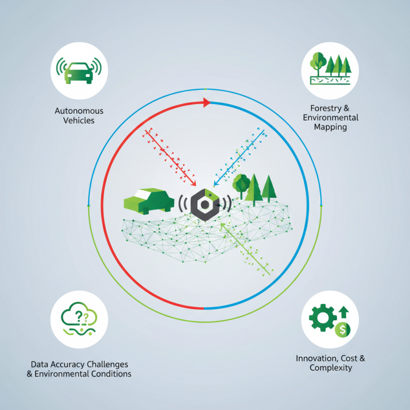
The Lidar Sensor operates by sending laser pulses that reflect off surfaces. This mechanism allows the creation of detailed 3D maps. Industries like autonomous vehicles and forestry rely on this technology for improved safety and efficiency. Despite its benefits, challenges remain. Data accuracy can vary with environmental conditions. Understanding these limitations is crucial for successful implementation.
Innovations continue to evolve within Lidar technology. Newer models aim to enhance resolution and range. However, cost and complexity can hinder widespread use. Bridging these gaps is vital for the future of Lidar Sensor applications. The future looks promising, yet reflection on current shortcomings is necessary.
Definition and Overview of Lidar Sensors
Lidar sensors have become essential for various industries. They are instruments that use laser light to measure distances. By emitting rapid pulses of light and recording the time it takes for each pulse to return, Lidar creates highly accurate 3D maps. According to recent reports, the Lidar market is expected to reach over $3 billion by 2026. This growth is driven by its use in autonomous vehicles, surveying, and environmental monitoring.
When using Lidar, precision is crucial. Data accuracy can vary with environmental conditions. For example, heavy rain or snow can affect results. A well-calibrated Lidar system can provide data with an accuracy of fewer than 5 cm. However, it is important to acknowledge that not all Lidar systems are equally efficient. User experience is vital in determining effectiveness.
Tip: Regularly maintain and calibrate your Lidar sensors. This ensures optimal performance and reliability. Understanding the hardware's limits can prevent inaccuracies in data collection. Often, users overlook the importance of software updates, which can enhance functionality. Always keep your equipment updated.
Principles of Lidar Technology and Operation
Lidar technology utilizes laser light to measure distances. It works by emitting laser pulses and measuring the time it takes for the light to bounce back. This helps create detailed 3D maps of environments. The precision of these measurements can reach within centimeters. According to recent industry reports, the Lidar market is expected to reach $1.7 billion by 2027, driven by advancements in automation and mapping technologies.
The principle is straightforward but has complexities. Different scanning methods exist, such as airborne or terrestrial systems. Each method has its specific applications. For instance, airborne systems are often used in large area mappings, like forests or cities. However, their results can be inconsistent due to weather conditions. Terrestrial systems are best for detailed analysis but have limited ranges. A report by the Geospatial World highlights that environmental factors can disrupt the accuracy of a Lidar sensor’s data collection.
In practice, achieving optimal results using Lidar can be challenging. Calibration is essential for reliable data. Even a slight misalignment can lead to significant errors in mapping. Additionally, while Lidar sensors can capture large datasets, processing these datasets is another hurdle. The complexity of handling such data opens doors for innovation but also requires careful management to avoid inaccuracies.
Types of Lidar Sensors and Their Applications
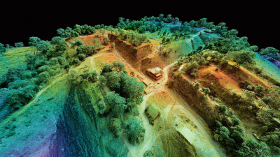
Lidar sensors are evolving technology with various types tailored to specific applications. The two primary categories are airborne and terrestrial Lidar sensors. Airborne Lidar, mounted on drones or planes, captures large areas efficiently. It is commonly used in forestry to assess tree heights and biomass. Terrestrial Lidar, on the other hand, operates from fixed locations. This type often aids in construction and infrastructure projects, providing highly detailed measurements of buildings and landscapes.
Data from industry reports indicate that the global Lidar market is anticipated to reach $2.7 billion by 2025, growing over 20% annually. The increase is driven by advancements in sensor technology and rising demand across sectors. For instance, the automotive industry is investing heavily in Lidar for autonomous vehicles. However, challenges remain, such as integration costs and operational complexities.
In agriculture, Lidar can assist in precision farming. It offers data on crop health and soil conditions. A study showed a 15% increase in yield for farms implementing Lidar-based monitoring. Yet, variability in terrain and weather can affect accuracy. Ensuring reliable usage in diverse conditions is key. Therefore, while Lidar sensors offer great potential, ongoing refinement is necessary to maximize their effectiveness.
What is a Lidar Sensor and How Does it Work? - Types of Lidar Sensors and Their Applications
| Lidar Sensor Type |
Working Principle |
Applications |
Range |
| Pulse Lidar |
Emits laser pulses and measures the time it takes for the pulse to return. |
Topographic mapping, forestry, environmental monitoring |
Up to 1000 meters |
| Phase-Shift Lidar |
Measures the phase shift of reflected laser light. |
Drone mapping, autonomous vehicles, civil engineering |
Up to 2000 meters |
| Waveform Lidar |
Analyzes the entire return signal to gather more detailed information. |
Vegetation profiling, urban modeling, archaeological site analysis |
Up to 1200 meters |
| Multichannel Lidar |
Uses multiple channels to capture more data simultaneously. |
Traffic monitoring, 3D mapping, disaster management |
Varies by system |
Advantages and Limitations of Lidar Technology
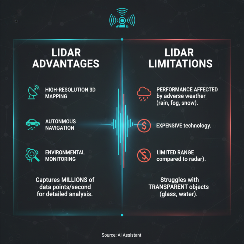
Lidar technology offers both advantages and limitations that are worth exploring. On one hand, it provides high-resolution 3D mapping capabilities. This makes it invaluable for applications like autonomous navigation and environmental monitoring. Lidar sensors can capture millions of data points in seconds. This precision enables detailed terrain analysis and object detection.
However, Lidar has its downsides. It can be quite expensive, making it less accessible for small projects. Factor in the need for a clear line of sight, and one might face challenges in dense environments. Signal interference from rain or fog might also reduce its effectiveness.
Tip: Consider your project's budget and environmental conditions before choosing Lidar. If you're working in urban areas, be prepared for potential limitations. Surroundings can affect performance. Analyzing these factors might save time and resources in the long run.
Despite its impressive capabilities, Lidar isn't a catch-all solution. Users should reflect on the technology's suitability for their specific needs. Understanding both the advantages and limitations can lead to better project outcomes. Always weigh cost against benefits to make informed decisions.
Future Developments and Innovations in Lidar Systems
Lidar technology is evolving rapidly. The future of Lidar systems holds exciting possibilities. Companies are exploring new methods to enhance accuracy and efficiency. Advanced algorithms might improve data processing significantly. These innovations could lead to real-time applications. For instance, instant mapping in urban environments could become standard.
Moreover, integration with artificial intelligence is a promising direction. AI can analyze Lidar data with precision. This combination may enhance object recognition and tracking. Imagine drones navigating complex terrains seamlessly. However, the technology still faces challenges. Data interpretation can be inconsistent. Anomalies in readings may skew results. Researchers must address these issues.
Sustainability is also a focus. New materials and methods may reduce environmental impact. Compact Lidar sensors are emerging, making them more accessible. These smaller units can fit in various devices, from cars to smartphones. As developments continue, thorough testing is essential. Continuous improvement will push Lidar to new heights. The future looks bright but requires careful navigation.
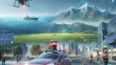
Lidar Sensor Applications and Market Growth